Episodes >> Ozone
Examples of photochemical
pollution episodes
- At the end of June, the beginning of July, 2009 : Animation of the episode
- August 2003 : description of the episode
- August 2003 : forecasts of the PREV'AIR system
- Références
August 2003 : description of the episode
From the 1st to the 15th August 2003, anticyclonic conditions prevailed over Western Europe, thus favouring the development of a photochemical pollution episode. This episode was out of range with respect to its geographical extension, its duration and the ozone levels that were encountered. In France, 417 µg/m3 were reached near Marseille, and the population information threshold for this pollutant (i.e. 180 µg/m3, hourly mean concentration) was exceeded several times all over the French territory and in many neighbouring countries.
|
On the right-hand side, the map displays the ozone ground concentrations (in µg/m3) on August 8, 2003, 2 p.m. Isolines display the simulated concentrations - a posteriori - by the CHIMERE model; points refer to in-situ observations (carried out by local air quality monitoring networks). Exceedances of the 180 µg/m3 threshold are in black. This picture shows the continental extension of the August 2003 photochemical episode. Almost all French regions were touched, including remote places (away from large emission centers such as cities, industries) or usually clean areas (Atlantic sea-side or Brittany). |
August 2003 : forecasts of the PREV'AIR systema name="II">
In 2003, the PREV'AIR forecasts accounted well for the course of the photochemical episode.
At the beginning
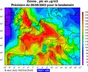
The three-day forecasts of July 31, 2003 show the shift from a slightly polluted situation (under the influence of the clean masses of air of oceanic origin) to already high ozone levels (see the forecasts for August 2, 2003) over almost the whole of France - except for the most North-Western part - and the North of Europe (Belgium, Netherlands, Nord-West of Germany) and Northern Italy.
In the middle of the episode
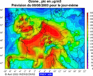
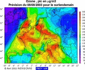
Based on the forecasts of August 8, 2003, concentrations were expecteed to exceed 180 µg/m3 over a large area, extending from North-East to South-West, from Netherlands to South-West of France, as well as over the South of England , Northern Italy and the Portuguese coast.
It appears that the forecast levels were overestimated compared to the observations. On the other hand, the extent of the polluted field was correctly estimated in the forecast maps.
The end 
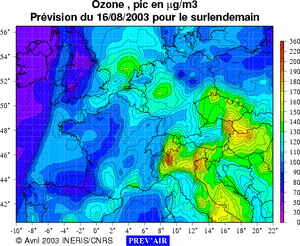
On August 16, 2003, the three-day forecasts show a progressive return to a slightly polluted situation under the influence of the clean air masses of oceanic origin.
References 
Vautard, R., Honoré, C., Beelmann, M. et L. Rouïl, Simulation of ozone during the August 2003 heat wave and emission control scenarios, Atmospheric Environment, Volume 39, Issue 16, May 2005 , pages 2957-2967
in PREV'AIRAir Quality forecasts in
the PREV'AIR SystemAnalysed MapsVerification Available observation dataInput Data to the PREV'AIR SystemRequest for the Provision of Air
Quality Numerical Simulation DataLe programme CarpateDétail de la PrévisionChronogramme Nitrogen dioxide Forecast Ozone ForecastAOT MODEL - AOT SATELLITES PM 2.5 Forecast PM 10 ForecastForecast Desert dust Analysed Ozone mapsAnalysed PM 10 maps Ozone Observation Nitrogen dioxide Observation PM 2.5 Observation PM 10 ObservationVerification of the Ozone forecastsVerification of the Nitrogen dioxide
forecastsVerification of the PM 10 forecastsBilan Annuel : GénéralitésDépassement de seuils en heuresDépassement de seuils en jourAOTsMoyenne des picsStatistiques O3Statistiques no2Examples of photochemical
pollution episodesExamples of particulate
pollution episodesAvertissementLiencontactThe partners in PREV'AIR


